
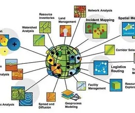
A Specialist in Geospatial Data Analysis is responsible for deriving actionable insights from location-based information by applying advanced analytical and spatial techniques. Geospatial data analysis involves collecting, manipulating, processing, and visualizing data tied to specific geographic locations, such as GPS coordinates, satellite imagery, digital maps, and address-based datasets, to uncover meaningful spatial patterns, trends, and relationships.
This role combines expertise in Geographic Information Systems (GIS), remote sensing, spatial databases, and statistical analysis to interpret complex geographic phenomena. By integrating diverse datasets—including terrain, climate, rainfall, land use, and historical event records—the specialist enables accurate spatial modeling and decision support.
In disaster-prone regions such as the Himalayan belt, geospatial data analysis is critical for understanding environmental risks. A specialist analyzes topography, drainage networks, rainfall intensity, and historical cloudburst occurrences to identify vulnerable zones and support early warning and disaster mitigation systems.
With the integration of Artificial Intelligence (AI) and Machine Learning (ML), geospatial analysis can automatically detect hidden spatial correlations, predict future risks, and improve model accuracy over time. The specialist plays a vital role in translating complex spatial data into clear visual outputs such as maps, dashboards, and alerts that support timely, informed decision-making.